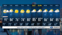
Hazy, hot and humid weather continues today. Air quality is down a bit and heat indices are up in the in the low 90s.
High humidity will linger through the day with highs reaching into the upper 80s for most areas. Clouds will be on the increase throughout the day.
Overnight, showers and t’storms ahead of an approaching cold front will march across New England this evening. We’re expecting showers and t’storms to wane after sunset as the best instability and convective parameters diminish with the loss of daytime heating.
Any storms that survive the trek east will be capable of producing damaging wind gusts. Lows will only drop into the upper 60s to low 70s towards the metro centers.
Get New England news, weather forecasts and entertainment stories to your inbox. Sign up for NECN newsletters.
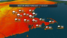
Tuesday will be a somewhat wet and muggy day as another round of showers trail behind a cold front passing through the region. High temperatures will reach into the upper 70s to low 80s. Winds will shift to the northwest behind the cold front.
High pressure will build into New England on Wednesday. Expecting a mostly sunny day, aside from some mid-level clouds. Much cooler and drier with high temperatures reaching into the mid 70s.
High pressure will move offshore on Thursday with dry weather holding strong. Temperatures will yet again rise into the mid 70s, low 80s in the Connecticut River and Merrimack Valleys.
A building ridge in the Mid Atlantic Ocean will usher a return southwest flow across the Northeast, drawing in potential clouds and showers. Looking ahead to the weekend on the exclusive First Alert Weather 10-Day Forecast on NBC10 Boston and NECN, showers and scattered t’storms will threaten each day.