
Showers and downpours continue to expand over us at the same steady rain moves in from west to east this evening.
Big warm up and heavy rain
It’s all courtesy of a warm front that’s making slow northward progress across the region. Temperatures will continue to gradually rise through the 40s and 50s this evening and overnight. The wind is already kicking up too, and gusts 40-50 mph between 11 p.m. and 5 a.m. will cause pockets of damage and outages. The rain will taper overnight to just a few areas of showers by Wednesday morning.

Get New England news, weather forecasts and entertainment stories to your inbox. Sign up for NECN newsletters.
Rainfall totals will generally range from ¼” to ¾”, though locally higher amounts are possible in western New England. The combination of rain and melting will elevate our risk of flooding and ice jams tonight through the day tomorrow across Vermont, New Hampshire and western Maine. Tomorrow is all about our taste of early spring; temperatures will challenge but may fall just shy of record territory, rising into the 60s.
Temperature drop and a Friday snowstorm
After a warm morning, northern New England will see falling temperatures for the remainder of the day as colder air makes its comeback. In fact, it’ll be a substantial snap back to reality with highs only in the 30s again on Thursday.

That cold air remains in place as our next storm approaches. There are still many details to be ironed out, but here’s our latest thinking…snow will arrive overnight Thursday, around midnight in southern New England. Snow expands northward overnight so that by Friday morning, it’s snowing in much of the 6 state region, with the exception of northern Maine. The “height” of the storm will be pre-dawn Friday until midday, though areas of lighter snow will linger into the evening. Some mid-level warming will flip the snow to sleet in parts of southern New England Friday afternoon, perhaps along and south of the Mass. Pike. How quickly that transition happens and how far north the mixing will go is still uncertain. Where we do make a changeover, a flip back to snow is likely in the evening Friday as the wind shifts around to the north and drags in colder air.
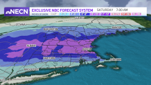
How much snow are we getting Friday?
Weather Stories


A widespread 6-12” of snow seems likely for many of us, with lesser amounts along the south coast (with the mixing) and the far North Country (farther away from the storm). Though the onshore wind will be gusty at times Friday, tides are astronomically lower and our coastal flooding risk is low. The sun returns on Saturday and Sunday will feature the chance of a few snow showers as a reinforcing shot of cold air comes in. Highs on Monday will struggle to get out of the 20s. Stay tuned for storm updates!
