
An upper level storm parked just north of the Canada border with New England is responsible for a sprawling swirl of cool air and atmospheric energy aloft, which favors the development of clouds and precipitation.
As a result, splashes of Tuesday sun will remain limited as clouds continue to dominate – the most sun will be seen in far southern New England, farthest from the upper level storm – with increasing scattered showers and embedded downpours as the day wears on. While most of the showers will develop and be found over interior New England, some of these will inevitably drift east to the coast and by evening just about all of New England is equally game for showers that will only very slowly diminish during the first half of the overnight.
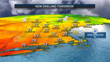
With partial clearing toward dawn Wednesday, as drier air filters through the New England sky, Wednesday will bring a blend of sun and clouds with a pleasant air and a light wind affording a rebound of temperatures into the 70s south and 60s north, with a dry day until the late day or evening arrival of a quick-moving disturbance aloft that may touch off some evening showers from Upstate New York to western New England.
Get New England news, weather forecasts and entertainment stories to your inbox. Sign up for NECN newsletters.
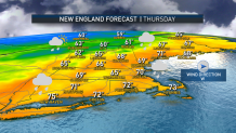
An approaching cold front Thursday will focus a few hours of rain and embedded thunder from northern New England (morning) to southern New England (late morning into mid-afternoon) before opening the door to a northerly wind that will keep Friday dry but chilly, with daytime highs only struggling to reach 60 degrees!
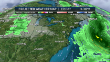
Some of this wind will be hastened on the back side of strong Hurricane Fiona, a Category 3 storm just north of the Turks and Caicos Tuesday morning and forecast to reach Category 4 strength as it passes near or just west of Bermuda Thursday night with a big blow to the island. Waves will emanate from Fiona and build up and down the eastern seaboard with dangerous rip currents and challenging conditions for mariners from Thursday through Saturday as wave heights reach 15 to 25 feet near and just outside of George’s Bank.
As Fiona weakens to Category 2 strength Friday night into Saturday, the storm is expected to pull north across the Canadian Maritimes, dealing a blow of gusts 80-100 mph to eastern Nova Scotia and especially Newfoundland, resulting in multiple power outages. The New England offshore fishing community should avoid the Scotian Slopes and Grand Banks, where swell will start building Thursday but hurricane conditions are expected Friday night into Saturday.
On land here at home in New England, dry air behind the hurricane should deliver a great fall weekend both Saturday and Sunday before the next round of showers arrives Monday, perhaps lingering as showers into part of Tuesday before departing in our exclusive First Alert 10-day forecast.
