
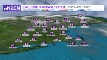
A weak cold front crosses the area early on Wednesday morning. There is a very slight chance of seeing a shower as the front basically “dries up” as it closes in on the Massachusetts Turnpike.
Skies will quickly go from clouds to sunshine and winds will increase. Dew points will be very low, and the risk for brush fires will remain very high. High temperatures will be much cooler, in the lower 60s.
The fire danger will remain high on Thursday as well, although winds will subside slightly. Highs will be in the upper 60s.
Get New England news, weather forecasts and entertainment stories to your inbox. Sign up for NECN newsletters.
Friday is mostly sunny and very nice — highs in the lower 70s are likely. With higher dew points, the risk of wildfires will slowly diminish. Much needed rain is likely by Saturday afternoon. Skies will be cloudy most of the day, and temperatures top out around 70 degrees.
The rain will linger into Sunday morning, but as it appears now, Sunday afternoon will be beautiful. Highs Sunday will be in the upper 70s. Monday is partly cloudy — and cooler — with highs in the upper 60s.
