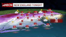
Temperatures continue to slowly fall this evening and we have a First Alert for the bitter cold heading in.
Lake Effect snow showers or flurries continue to stretch all the way from Lake Ontario thanks to the arctic airmass moving in above. Ocean effect snow showers will develop on or near the outer Cape with the northwest flow over Cape Cod Bay. A couple inches of accumulation is possible through Tuesday morning.
Monday night's lows drop to the single digits, and below zero north. Any light breeze will add to the extreme chill. A west, northwest wind between 10 and 20 mph will make it feel like -10 to -20 degrees by Tuesday morning.
Get New England news, weather forecasts and entertainment stories to your inbox. Sign up for NECN newsletters.
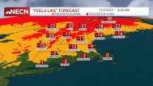
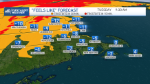
Wind chill advisories are in effect for much of northern and interior central New England Monday night into Tuesday. This means that you need to limit time outdoors and cover up skin. Frostbite can set in in 30 minutes or less, to 15 minutes or less with wind chills up north below -20. Highs Tuesday will be the coldest since January 2019, when Boston was 10 degrees for a high on the Jan. 29. We’re going for a forecast high of 14. Highs in the north country stay in the single digits.
Our temps make a comeback quickly with highs back in the low 30s Wednesday, mid-30s Thursday. Friday we cool to the 20s with an ocean storm passing nearby Thursday into Friday. Some snow may graze the southeastern parts of New England, increased waves and gusty winds are also possible. We will watch this closely as we go through the week.
This weekend we keep a few snow showers around, with highs in the 20s. Another ocean storm passes by early next week.