The broad upper low that’s been sitting over the Great Lakes producing storms across the Mississippi Valley, Midwest and now the east coast, will keep feeding our atmosphere through Saturday night.
While our first round of rain works its way out, the sun and mild temperatures will brew the atmosphere for a while setting up the stage before our second round precipitation moves in.
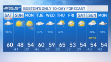
This second round tags along storms triggered by the cold and dry air behind a front that’s encountering a moist and mild set up. Highs today reach the 60s but the cold front is carrying 30s and 40s right behind it. That’s what our weather will be like Sunday along with blustery winds that will make it feel like the 30s instead.
Get New England news, weather forecasts and entertainment stories to your inbox. Sign up for NECN newsletters.
While the sun will shine bright on our Sunday afternoon, being under the shade outside will feel like the 20s and 30s with northwest wind gusting up to 35 mph at times.
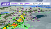
Our imminent threat, however, is Saturday’s potentially damaging wind gusts that will accompany these storms. We already have a windy day for parts of southeastern Massachusetts where the southwest flow has been gusting up to 50 mph.
Saturday evening, the storms may bring such energy that the downdrafts may produce up to 60 mph gusts in localized areas along with heavy rain and potential hail. Thunder will be another one of those risks, staying away from doors and windows will be the safest thing to do this evening as the storms march through.
Weather Stories


A severe thunderstorm warning that was issued for parts of central and southern New Hampshire, including Rockingham, Strafford, Hillsborough and Merrimack counties through 9:30 p.m. has since expired.
The National Weather Service said radar indicated there was a severe thunderstorm over Hooksett, or near Manchester, just before 8:50 p.m., moving east at 35 mph. The hazard included 60 mph wind gusts and quarter size hail with both wind and hail damage possible.
A severe thunderstorm watch that was issued earlier Saturday for portions of western Connecticut and western Mass. was also cancelled.
Click here for active weather alerts
Once storms move out overnight, a few sprinkles east and flurries may remain in higher elevations that will depart before sunrise allowing bright sunny skies to dominate over Sunday.
Another warm front ushers in Monday which will cause our pressure gradient to increase as a high pressure sits to our southeast allowing for wind gusts to take their protagonist role one more time.
Highs by that time will rebound to the 50s. Rain chances come back Monday night, Tuesday through Thursday with highs ranging in the upper 50s to mid-60s. The warmest day is likely Thursday where parts of the southwest could see highs nearing the 70s.