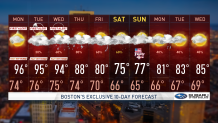
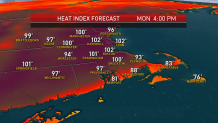
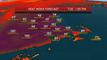
Our weather team continues to issue a First Alert for impactful heat through Wednesday. High temperatures are forecast to reach the middle 90s for most Monday, Tuesday and Wednesday, with humidity helping to create heat index values around and over 100° each afternoon.
Keep in mind that heat index is a way of representing the impact of combined heat and humidity on the body. One could interpret the readings as: “if the humidity were lower and closer to normal, the temperature would have to be 100° in order to have this kind of impact on the body.”
Nonetheless, the tips for heat safety are the same: stay hydrated, wear lightweight, light-colored clothing and check on those who may need some help. Human bodies on either side of the age spectrum – younger and older – have a bit more trouble regulating temperature.
Get New England news, weather forecasts and entertainment stories to your inbox. Sign up for NECN newsletters.
Pets will need shade and water on these days and keep in mind cars heat remarkably fast. Finally, it’s a great idea to check your car's tire pressure today, as underinflated tires can blow out in hot conditions like this.
Although there’s no much hot and cool clash for storms to develop in southern New England Monday afternoon, the air aloft is cooler across northern New England and Upstate New York. Afternoon storms are likely in the area and will feed off the warmth and humidity to become strong and damaging with strong wind gusts, frequent lightning and briefly torrential rain.
Although a storm may wander from New York into southern New England Monday night, that’s not extremely likely. Tuesday we see cool air aloft settling farther south, meaning afternoon thunder becomes more likely into central New England and possible in southern New England during the afternoon and evening.
On Wednesday, the chance rises even more as a slow-moving cold front approaches New England from the north. Although the cold front will spell the end of the deep heat by Thursday, it will likely move slowly enough that we’ll find a number of showers, downpours and thunderstorms Thursday with humid air still in place.
We’re likely to find much cooler, less humid air Friday into the holiday weekend, though the chance of showers still will remain elevated as the cold front doesn’t shift far south of us.
Our team’s hope is the amount of showers will gradually diminish each day through the holiday weekend but there’s still an elevated chance of at least some showers on the Fourth of July. Things look to improve by Monday, July 6 and into early next week in our exclusive First Alert 10-day forecast.