
The hot spell rolls on. We should make it an official heat wave in Boston Thursday with the third consecutive day of 90 plus degrees. A lot of people are already waving the white flag in this heat, but we’re just getting started. And there are signs that triple digit temperatures are on the horizon.
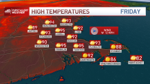
Thursday's numbers are again split between the coast and "everywhere else." Feeble sea breezes on the North Shore and New Hampshire Seacoast will temper some of the afternoon heat, but elsewhere, mid-90s are fair play again. There will be a wind Thursday too. Gusts could hit 20-25 miles per hour at times as a weak front glides in our direction.
Get New England news, weather forecasts and entertainment stories to your inbox. Sign up for NECN newsletters.
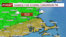
This front will heighten the risk for thunderstorms later in the afternoon. Right now the risk remains greatest from I-128 to outer Rt. 2 and across most of southern New Hampshire. It’s here that the unstable air is greatest and the lift in the atmosphere is sufficient. Elsewhere, our risk is small, or even diminutive. Think 5 to 6 storms north, and 1 to 2 to the south. Even with some heavy rain in some storms, this is no panacea for the drought.

We’re really getting a clobbering this weekend in terms of heat. The hottest part of this airmass will shift overhead and combined with full, hazy, sun, we’re pushing the century mark in spots by Sunday. Heat indices will be in the well over 100 degrees, so this will be a VERY dangerous combination if you're attempting to do anything outside for a long period of time.
Thunder finishes off the hottest part of this spell by Monday afternoon, and we should see the heat ease by Tuesday.
Weather Stories


Keep it cool and stay hydrated!
