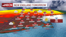
Heat and humidity continue to take over New England.
Heat advisories have been extended to tomorrow night and stretch from Connecticut out to coastal Maine, with the heat index rising to the triple digits both today and tomorrow.
Our chance for storms continues this afternoon. We’ve seen downpours moving from west to east, but limited across southern New England so far. Most of these cells have been marching through Vermont and New Hampshire, reaching Maine this evening and lasting through tomorrow morning across the Canadian border and areas of northern Maine.

Get New England news, weather forecasts and entertainment stories to your inbox. Sign up for NECN newsletters.
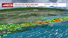
We keep our chance for isolated to scattered storms tomorrow but the coverage and intensity will likely increase on Tuesday. A cold front sets in and brings heavy rain over much of Maine Monday night into Tuesday with more storms along northern New England Tuesday. That same energy increases on Tuesday afternoon once its set over central New England, which brings heavier pockets of rain, thunderstorms and possible hail over much of Massachusetts and our southern communities. Timing is not set in stone, but it seems to propagate stronger storms by mid to late afternoon and towards the evening. Lightning, heavy rain and localized damaging wind gusts remain to be the main threats.

With the passage of this slow-moving cold front, our temperatures are finally ready to dip into the 80s for Wednesday. Much of northern New England is ready to see highs in the 70s, too. In the 10-day forecast we keep rain chances through the end of the work week with a more seasonable stretch of highs in the lower 80s.

