The heat in Boston has broken a record that stood for nearly a century.
Boston hit 97 degrees Wednesday, exceeding the previous record temperature of 96 set on this date in 1928.
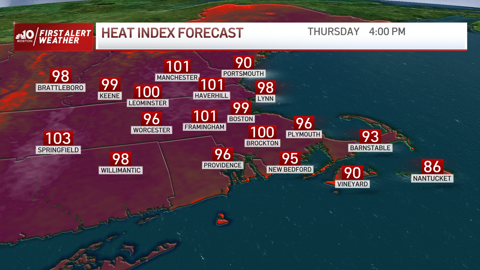
Scorching heat takes over New England Thursday afternoon, marking it the hottest day of the week. That's thanks to highs in the 90s and heat indices reaching upper 90s or three digits for some.
Get New England news, weather forecasts and entertainment stories to your inbox. Sign up for NECN newsletters.
It’s a day to take it easy, stay cool and hydrate. Heat advisories stretch from southwestern Connecticut out to Penobscot County, Maine and our humidity is no joke. It brings a suffocating feel to the air as it rises to the 70s in our coastal communities and upper 60s along our inland spots.
While temperatures drop slightly Friday, humidity increases even more and that will bring heat indices up to the three digits once again. Take breaks and stay under the shade if you must be outdoors, however our recommendation remains to stay inside with AC on. Air quality is also unhealthy Thursday afternoon and sensitive groups are also advised to avoid the outdoors.
It’s a long First Alert stretch that keeps us weather aware from Thursday through Monday. Whether it’s the heat or the storms, our region will undergo impactful weather in the next few days.
With a cold front lingering in Friday, we’ll see the chance for more sustained rainfall reaching west to east across our mountains and up to the coast. These storms may be slow moving but bring the chance for heavy rain.
Some localized areas may see the possibility of ponding or flash flooding as they push through due to the torrential rainfall in a short amount of time. Thunder, localized wind gusts and heavy rain remain to be the highest threats for now.
Our weekend is setting up for a hot and humid stretch, highs will remain near or over 90 degrees and the chance for storms will pop up through the afternoon across central and northern New England. Storms seem to increase their coverage on Monday for which we’ll keep First Alert up until then. Temperatures start to drop to the lower 80s Wednesday on to the end of the work week.