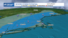
The start to the summer season has arrived and we have a mostly beautiful holiday weekend in store weather-wise! A First Alert has been issued for today for scattered strong to isolated severe thunderstorms this afternoon and evening.
This morning we have some fog, drizzle, and low clouds across the south coast, cape and islands. Plus some showers and thunderstorms rolled through early, so the yards are wet and muddy in spots from the downpours.
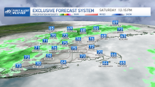
As we dry off and as the sun peaks through a bit inland we warm things up. Clouds may linger across Cape Cod for most of the day, but this will keep the airmass more stable, which is important for those later storms. Highs will be in the 60s there, then in the 70s to low 80s inland and where we see more sun.
Get New England news, weather forecasts and entertainment stories to your inbox. Sign up for NECN newsletters.
By noon time we anticipate storms to pop up in the heat of the afternoon. The more sunshine we see, the more storms and the stronger the storms will be. Damaging wind and hail are the main threats from any storm today.
Also watch for lightning and heavy rainfall. The storms will last through sunset, and they head into the Merrimack Valley around 3-6 p.m., and around Boston 5-8 p.m. as the sun is setting and as we lose our daytime heating.
Warnings for flash floods have also been given in certain parts of Maine.
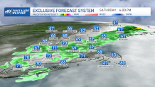
The storms continue to slowly weaken as they head towards Cape Cod around 8pm. The rain heads offshore after then and we’re done with the rain for the rest of the long holiday weekend.
Sunday is gorgeous with highs in the mid to upper 70s near the coast and around 80 inland under full sunshine and low humidity. Memorial Day heats up again as we see a warm airmass return and a westerly breeze. Inland highs reach the low 90s, while 80s are found at the coast. Memorial Day services and ceremonies will remain all dry, though feeling a tad humid.
A backdoor front may cool us off dramatically in eastern New England for Tuesday through Thursday. Highs may be stuck in the 70s to low 60s with an east, northeast wind and clouds. Meanwhile, inland highs reach the 80s to 90s with sun.