The holiday weekend is here! And the forecast is anything but consistent in the next three days. We’ll go from the frying pan today to a thundery, sticky Saturday. We’ll finish in fine fashion with lower humidity and plentiful sun.
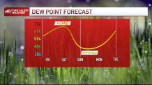
First up, the heat of the day. Sizzling temps in the 90s are in store. May sound like a scorcher, but what’s tolerable about the day is the humidity. It will take some time to bring in the muggy air, with a noticeable change arriving after 4 or 5 p.m.
Gusty southwest winds are bringing in the higher dew points, with speeds that may peak near 30 mph later in the afternoon on both Capes. Expect winds of 20-25 elsewhere.
Get New England news, weather forecasts and entertainment stories to your inbox. Sign up for NECN newsletters.
The storms will fire in the early evening across western New England, then travel eastward through the night. Some may contain frequent lightning and heavy rain. These will bleed over into Saturday morning as a cold front inches in from the west.
It’s not a washed out Saturday forecast, but the wet weather will loom over a good part of the day. As the front weasels down across southeastern Massachusetts in the afternoon, skies will break for some sun north of a line from Worcester to Concord, Reading and Marblehead.
The Merrimack Valley and most of southern New Hampshire have the best shot a seeing a few hours of sun. It’s here that the best chance for storms or rain is in the morning. South and southeast, the threat for some more intense storms and/or severe weather exists.
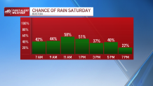
The primary threat from these storms will be torrential, flooding rain, gusty winds, and small hail. Keep an eye to the sky in the afternoon.
Sunday and Monday are the “make goods” on the weekend forecast. Highs both days bounce back to the 80s as the humidity is lowered back to the tolerable range (dew points in the 40s and 50s…ahhh).
Be safe, have fun and enjoy the holiday weekend!