
Flash flood warnings were in effect in parts of Vermont Monday afternoon into the night, but they have since expired.
Click here to see active weather alerts.
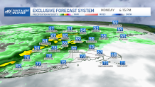
Varied temperatures across New England
A backdoor front has settled in across the northeast and that means a big variation in temperatures today.
Get New England news, weather forecasts and entertainment stories to your inbox. Sign up for NECN newsletters.
Across Maine, highs will stay in the 50s to 60s, with Boston also sitting in the 60s for much of the day thanks to a northeasterly flow. Around Hartford and in western Massachusetts we see temps in the 70s to near 80 thanks to the warm sector and a southerly flow.
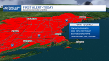
First Alert for storms moving in this afternoon and evening
Weather Stories


The front will contribute to lift and some sunshine will lead to instability and this means a First Alert day/evening for strong to severe thunderstorms. Damaging wind, hail, heavy rain and lightning are the main threats. The storms and showers will not be quite as strong as they head into the more stable airmass over northern and eastern New England tonight. Downpours and some thunder will be likely in Boston around dinnertime.
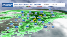
The low-pressure system will still be to our north and nearby through tomorrow. That means scattered showers are likely Tuesday afternoon as temps stay fall-like and in the 60s. Wednesday we get a break with more sunshine and highs in the low 70s. Then another cold front approaches Wednesday night into Thursday and this system may also bring scattered severe thunderstorms.
After this wave of rain, we see the coolest air of the season for Friday! Highs only reach the 50s and 60s with a gusty wind. Then a slight warming trend returns for the weekend as we see 70s again.
