
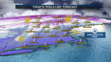
The wind chill continues to feel below zero Saturday afternoon across the north and inland spots in central New England.
For the evening, we’ll be tracking wind gusts over 20 mph, keeping our "feels like" temperatures near zero to subzero. If you have plans, make sure you’re adequately layered up.
Needless to say, we’ll have a cold night and a frigid Sunday morning -- our highs on Sunday will increase to the upper 20s in the south and teens in the north.
Get New England news, weather forecasts and entertainment stories to your inbox. Sign up for NECN newsletters.
The sun will be out and our the will rapidly decrease early in the morning to single-digit speeds. It will be a calm day before the arrival of our next storm, but wind gusts will begin to pick up again late Sunday into Monday, bringing snow showers to the southwest.
Even though the snow will be brief, some flurries might make it near Boston, although with the track the low pressure is keeping, it is likely that the western track will switch snow back into rain towards the south and southeast.
Weather Stories


Temperatures in the upper 30s and low 40s will make sure that much of central and southern New England rain, but some snow may remain towards the Berkshires and up in the northern states.
Ski lovers: great news, this storm may drop over 7 inches of snow in the highest spots, and our models are showing isolated areas with a 10-to-12- inch range from Vermont to portions of New Hampshire and Maine.
A concern with this storm will be the mix in precipitation that might bring travel impacts and coastal effects, with the 40+ mph wind speeds increasing the chance of minor to moderate coastal flooding.
After that, our temperatures drop to the 20s on Tuesday, with the chance of snow showers by the second half of next week.
