
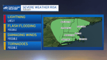
A flash flood warning was in place in parts of southeastern Massachusetts and Rhode Island at one point Tuesday as torrential rain moves into the area.
See the latest weather alerts here.
An NBC10 Boston First Alert has been issued for fog Tuesday morning, then rain and thunderstorms for the evening.
With the high humidity, foggy conditions will reduce visibility down to a quarter of a mile early in the day for coastal areas and inland. The fog is in advance of showers that we’ll see enter the region. Most of the region is dry prior to sunrise, then a shield of rain enters central Massachusetts around noon.
Get New England news, weather forecasts and entertainment stories to your inbox. Sign up for NECN newsletters.
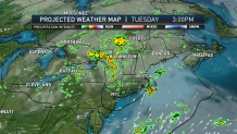
We’ll see this spread across the Boston Metro early afternoon to late evening. Another zone of heavy rain lines up along the South Coast. While the environment will be moisture laden, heavy rainfall isn’t widespread. The heaviest of rainfall tends to be isolated and in conjunction with damaging wind threat.
Wind gusts at times will exceed 50 mph. Tuesday’s tornado threat is low, but cannot be ruled out. Showers come to an end behind the cold front, and a refreshing fall-air mass settles in.
Weather Stories


Wednesday is dry, but warm. High temperatures are near 80 degrees. The day will be breezy with westerly winds between 10 and 15 miles per hour. The best of the refreshing air is delayed until Thursday and Friday, as northwesterly winds take hold of the region.
The second half the week features high temperatures in the upper 60s and low 70s. Humidity is scaled back significantly too. While not certain, longer range models hint at a late-season warm up for the second half of next week with highs in the mid-to-upper 80s.
