
The big weather event of the week is here. We’re seeing winds ramp up through the day as sprinkles and fast-moving showers turn to downpours late in the day.
While the winds increase uniformly, they will be especially strong during the “squall line” passage late Wednesday evening between 7 and 9. This is where the cold front will push heavy rain and possible (slight) thunderstorms through the region.
Power Outages Possible in Mass.
Get New England news, weather forecasts and entertainment stories to your inbox. Sign up for NECN newsletters.
Think of it as a line of summertime storms: they arrive and depart very quickly, with a frenzied burst of wind and rain. Tree limbs, small branches and power lines may come down during this time, so prepare for isolated outages.
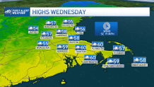
Mild Temperatures Wednesday
Weather Stories


Mild temperatures are in store for the day. Highs will nudge 60 in many spots on the heels of that warm south wind. Turning winds Wednesday night will bring us back to the cold and keep us there for the remainder of the week.
Highs Thursday struggle to make the 40 degree mark in most spots (likely won’t in Worcester), but the wind chill will be especially wintery. We’re expecting it to feel like upper 20s to low 30s all day long.
The cold gets the bounce by the weekend with more winds from the south. Highs will recover to the 50s as the showers move in during the afternoon. Sunday is brighter and colder.
We’ll go through one more iteration of the warmup/cooldown cycle before the pattern switches and brings in a more consistent, wintry cold late next week.
