
Sunny skies, lower dew points, highs in the 70s to low 80s, no rain… could we ask for more?
It’s a picture perfect afternoon. Our wind remains low, and our temperatures this evening will remain comfortable with clear skies.
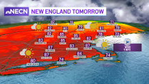
With a shift in our wind direction once again, our temperatures will increase tomorrow to reach highs in the upper 80s. It will be the warmest day of the week, we’re watching 80s for Boston too but 90s inland. Our skies will remain mostly sunny, but with increasing humidity, we’ll see more clouds filling in through the late afternoon too.
Get New England news, weather forecasts and entertainment stories to your inbox. Sign up for NECN newsletters.
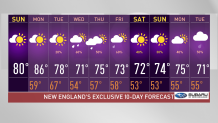
A backdoor cold front will push in cooler temperatures on Tuesday along the coast and Boston. While temperatures reach the 80s in western Massachusetts, our 70s remain for Boston with the chance of some upper 60s if the sea breeze persists for Boston.
Rain chances will increase Tuesday night into Wednesday, with scattered precipitation stretching through much of New England. Our rain chances will remain through the end of the week with mostly sunny skies on next weekend and overall highs ranging in the 60s to 70s for Boston, warmer inland.
Meanwhile, in the Pacific Ocean, we track our first hurricane of the Pacific Ocean season. It strengthened to become a hurricane while advancing slowly into Mexico. This tropical cyclone is expected to bring over 10” of rainfall, with a high risk of flooding, mudslides and destruction to the affected communities. Exiting through the Gulf of Mexico, this tropical cyclone may continue its path into the Atlantic- still too early to call it off- we’ll keep an eye on it; a better forecast can be expected by next weekend.
