The gloomy weekend blues are here to stay as snow continues to move along our region.
Snowfall totals will continue to add up north after having reports of more than 8" in northern Vermont, with 4"+ in the Berkshires. Even though the snow will end Saturday night for most of New England, northeastern Maine will see lingering snow through 4 a.m. Sunday.
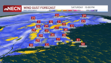
Our wind gusts will ramp up Saturday evening. As colder air surges eastward, velocities increase to 40 mph near our mountains and over 50 mph in southeastern Massachusetts.
Get New England news, weather forecasts and entertainment stories to your inbox. Sign up for NECN newsletters.
Minor wind damage is possible. Isolated power outages have resulted in a few areas as wet heavy snow has also played a role. Our visibility has been an issue, coming down to a quarter of a mile for some, but this will be an improving condition through the evening.
Our moisture levels decrease after we have the frontal boundary pushing through, keeping our snowfall totals low in the southern states and breaking the snow earlier, as well.
Temperatures drop Saturday night and our wind chills will come down to subzero in Vermont and New Hampshire, meanwhile in Massachusetts we’ll range from near 0 to single digits in the far southeast.
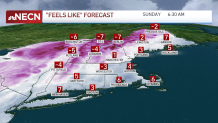
We’ll be enjoying sunny skies Sunday afternoon but our wind chills will keep it feeling in the 20s even at the peak of the day.
Also, considering our Daylight Saving Time starts Sunday, we’re having our sunset at a later time -- around 6:48 pm.
We climb to the 50s as soon as Monday and reach the 60s by the end of the work week.