
A weak storm center located over the eastern Great Lakes has induced a southwest wind across New England on Friday, delivering milder air, even more so than the already mild conditions we had Thursday!
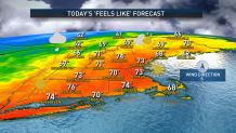
Variable early clouds with a few sprinkles represented one more push of warmth arriving aloft that will team with increasing sunshine to boost temperatures in the 70s Friday afternoon.
The cold front associated with the storm system to our west will arrive to New England from northwest, southeast Friday afternoon and evening, bringing a chance for scattered showers or even a thunderstorm to particularly northern, central and western New England, with a scattered shower possible in southern New England between 4 p.m. and 8 p.m. Friday evening.
The cold front will shift the wind to blow from the northwest, ushering in autumn air for the weekend. One final disturbance aloft, at the Jetstream level, will probably deliver a few showers Saturday morning to Southeast Massachusetts and Rhode Island but those should depart by midday and, elsewhere, dry conditions are expected with high temperatures in the 50s.
Get New England news, weather forecasts and entertainment stories to your inbox. Sign up for NECN newsletters.
Pockets of isolated frost are possible in the deep interior of southern New England overnight Saturday night where deepest valleys are sheltered from wind and cold air can pool, but most of Saturday night's frost will be found in central, northern and western New England.
Sunday brings a fair sky but building afternoon clouds will deliver a few scattered showers to the North Country in leaf peeping areas where color is approaching peak! Our exclusive First Alert 10 day forecast shows fall air through next week into next weekend with the best chance of a few showers on Monday and Thursday.
