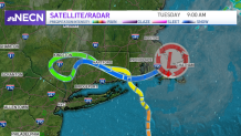
Henri is going to the record books with one of the most unique tracks of any tropical system to cross New England.
Henri came ashore near Westerly Rhode Island at noon time Saturday, looped westward through Connecticut to New York, then came back across Connecticut for a second time.
Finally at midnight Monday, 36 hours later, it crossed over the exact same spot where it made landfall, then proceeded east over the Cape Cod Canal and offshore at 9 a.m. this morning.
Get New England news, weather forecasts and entertainment stories to your inbox. Sign up for NECN newsletters.
Many parts of Connecticut, Rhode Island and western Massachusetts ended up with two rain storms from this, with total amounts of more than five inches reported by many weather spotters.
In addition, on the perimeter of the storm there were 3 EF0 mini-tornadoes (more like landspouts) in north central Massachusetts, without any thunder, on Monday afternoon. This was well away from the rain shield associated with Henri that was, at the time, generating another flash flooding event in Hartford, Connecticut.
Henri Coverage


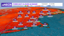
Most areas in eastern New England received more rain on Monday night than they had during the previous two days combined. In just a couple hours, two to three inches of rain fell south of Boston, and then parts of Maine Monday night, with some damaging thunderstorms in Duxbury, Massachusetts.
At Boston's Logan Airport, 1.69 inches of rain fell, making it a record for the day, beating 1.55 inches on Aug. 23, 1970. Now we are left with a very soggy ground and a warm to hot air mass.
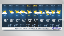
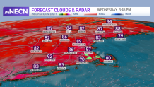
If the ground were not saturated, we would be forecasting a temperature of 95° this afternoon, but much of the sun's energy is going to evaporate moisture in the topsoil. This gives New England the feel of a greenhouse under partly sunny skies with a scattered shower this afternoon.
There will be patchy fog overnight, with mild and muggy air and low temperatures near 70°.
High pressure to our south takes control the next couple of days with a mixt of sun and clouds, spotty afternoon scattered showers or thunderstorms and high temperatures near 90° both Wednesday and Thursday.
The next front comes in later Thursday with a chance of more organized thunderstorms later in the day and at night. High pressure from Canada brings in less humid air Friday, but it’s still warm to hot with temperatures well into the 80s.
Wind from the east should supply cooler weather Saturday with a mix of sun and clouds. A warm front to our west may generate a shower or two on Saturday afternoon, with a better chance of showers and thunderstorms Sunday afternoon.
Warm and humid air will be poised to come back in early next week, as seen in our First Alert 10-day forecast.