Yesterday we learned that “remnants” of tropical systems can still pack a mighty punch, which is odd since Fred was over land for the last three days as it chugged north from Florida. (When cut off from their energy source – warm ocean waters – tropical systems typically weaken or even dissipate rapidly).
With three tornado warnings and even more flash floods, the storm lashed southern New England like it was fresh from a week in Keys.
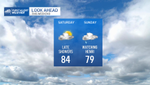
It feels like we’re in The Upside Down from Stranger Things. And unfortunately, there’s another Demogorgon coming through the gate. Two days ago, it seemed like a long shot for Henri to strike New England. Now it seems like we’re squarely in it for some affects, which could be significant.
Get New England news, weather forecasts and entertainment stories to your inbox. Sign up for NECN newsletters.
The National Weather Service and the National Hurricane Center issued a hurricane watch for Cape Cod and the Islands, which will remain in effect as tropical storm Henri heads toward the region and is forecast to strengthen to hurricane force. The hurricane watch extends to the coast of Rhode Island and southern Connecticut as well.
It’s been almost exactly 30 years since a hurricane (Bob) made landfall in New England, and Henri could be the storm that everyone says “is long overdue”. Granted it’s likely to be a Category 1 storm with max winds of 75 (ish) mph, but it’s still not something to take lightly.

Track is everything, and it’s also nothing. The wind field is likely to expand, so everyone could be under the gun for some strong and possibly damaging wind. Near the center and to the east of the storm’s track would be the most intense winds, however.
Weather Stories


In terms of rain, we could all see flooding. The ground is saturated everywhere thanks to Fred. But here again, points along and west of the track could see the most intense rain…on the order of 5-8 inches.
Like with an old ex, there are lots of unresolved issues. Will the storm slow to a crawl? There's some possibility of that. Will the westward drift in the track over the last two days mean the storm shifts toward Connecticut/Long Island? Also still possible. Is there a chance the storm could be stronger? Not likely. Do I need to cancel plans on Sunday? (Face palm.)
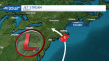
At issue is an upper level low pressure system (see graphic). This low is nudging the storm toward New England and also may be enough to slow the its forward speed. Both heighten our risk for landfall – and a miserable flooding event.
Some things to seriously consider:
- There may be thousands without power for days
- Flooding could be extensive
- Boats should to be brought to safe harbor/taken in
- Significant coastal flooding is possible with a storm surge
This makes it real. Let’s hope this is all an exercise in preparedness. But I’m thinking it’s likely not.