
Forging ahead through this busy pattern, we’re finding some days start with sun (clouds) and finish with clouds (sun). Such was tomorrow, and so will be today: bright start, then more clouds.
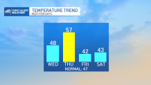
We’re also watching the temperatures start to tick up too. Highs climb close to 50 today, but soar close to 60 tomorrow on the heels of a gusty, mild wind. While today is kind of quiet, tomorrow will be the defining weather moment of the entire week.
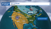
A strong disturbance will swing through the jet stream, potentially giving us wind gusts to 30 during the afternoon and throughout the night Thursday. Some of those gusts will come in during the cold frontal passage in the evening.
Get New England news, weather forecasts and entertainment stories to your inbox. Sign up for NECN newsletters.
This isn’t well depicted by our guidance, but experience has shown this to be a brief (but potent) little event. Expect the “fun” to start as early as 6 or 7 p.m. and carry through to around 9 or 10 p.m. moving from west to east.
The cold shot behind the front is significant, but the core of the coldest air will just brush us in southern New England. Friday’s highs are below normal, but still hover in the low 40s.
Weather Stories

Ditto for Saturday and Sunday as this cold remains embedded in the region. Saturday sees another weak system roll through with a couple of snow showers and flurries.
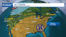
The longer range maps are hinting at another major shift in the pattern in the second week of December. I know what you’re thinking. “Stick to the 10-day, weather geek.”
Sure, I have no business even doing a 10-day, but with the signals we’re seeing, it will be hard to GET snow, never mind keeping it around for the holidays. Food for thought as we start off the final month of 2021.
Make it a great day!
