

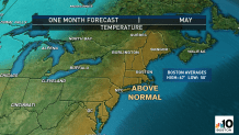
The first weekday of the month means a look ahead to the weather pattern for May and I was glad to deliver news of a probable warmer-than-normal month ahead. I was also glad to spread the word on behalf of our First Alert Weather Team of near-normal rainfall in May.
Here’s the thinking behind the forecast: the jet stream is likely to feature a persistent ridge over the Eastern Pacific in May, which is a bubble of high pressure, fair weather and somewhat warmer air.
In response, we’re likely to see a slight “trough” or dip in the jet stream over Central Canada and the Upper Midwest into the Western Great Lakes, leaving New England just ahead of this jet stream trough.
Get New England news, weather forecasts and entertainment stories to your inbox. Sign up for NECN newsletters.
What’s the meaning of a jet stream trough to the west of New England? Although the terms may sound like weather geekery, the bottom line is this: the jet stream is the fast river of air – a corridor of wind high in the sky – that steers disturbances and storms, and separates cool air to the north from warmth to the south. So, a trough, or dip in the jet stream, means cool air is pressing southward, so a trough position over the Upper Midwest and Western Great Lakes positions the strongest surges of cool air right there – not in New England.
In fact, often ahead of jet stream troughs we see spikes of exceptionally warm air from time to time, with cool shots moderating as they move east, so both of these factors together should mean a milder than normal May in New England.
One driving factor of a milder than normal month will be warm days later in the month (certainly not so much in the first 10 days!). But another will be the relatively mild nights, even present in the first couple of weeks with cloud cover on many nights holding the night temperature up.
As for precipitation, jet stream troughs in the spring are notorious for producing rain and thunderstorms – and often severe weather – ahead of them, where incoming cool air associated with the jet stream dip intersects warmth ahead of it.
Weather Stories


For this reason, we’ve pained above normal precipitation in some areas that have already been wet, like the Tennessee River Valley, extending north into the Ohio Valley. Of course, rain and thunder won’t necessarily stop there, but probably will carry into Pennsylvania, New York and the Appalachian mountains.
At home in New England, we’re likely to find a few if not several rounds of strong to severe thunderstorms in May – largely the result of the aforementioned spikes of warmth and progressively increasing humidity ahead of jet stream disturbances that may reach their most potent strength in the Upper Midwest and Great Lakes, but are likely to “round the bend” and head east with enough potency to trigger our own rounds of rain and thunder here in the Northeast.
For this reason, I’ve pained all of New England in near-normal precipitation…which would amount to over three inches of rain.
Keep in mind this is the first monthly forecast referencing the “new normals” – as you may have read in Meteorologist Chris Gloninger’s recent web post, each decade the meteorological community redefines “normal” based upon the past 30 consecutive years of data. For the month of May, this means the average high temperature for the month has been raised from 66.4 to 66.7 degrees, the average low increased from 50 to 50.4 degrees and the average rainfall for the month decreased from 3.48” to 3.25 inches of precipitation.
