
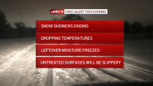
Pockets of light snow and snow showers will be tapering off and ending this evening, but additional coatings of snow will be possible before the conclusion of this event. The biggest impact this evening and tonight will be the dropping temperatures – which will fall into the 20s for many (teens far North Country) and freeze leftover moisture on anything untreated. Think driveways, parking lots, sidewalks etc…watch your step!
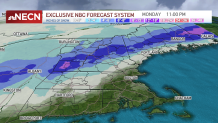
Meanwhile, we’re about 48 hours out from the onset of our NEXT weather system, slated to arrive to New England late Sunday. The energy associated with this next storm is currently over the southwest US and will dive eastward tomorrow, intensifying as it picks up some Gulf of Mexico moisture and tracks northward after that.
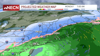
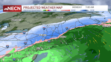
So what can we expect here at home? We know there will be a rain/snow line in play again, with plowable snow likely in Northern and Central New England, but the exact placement of that rain/snow line is still somewhat uncertain – an early guess would be north and west of Boston, perhaps outside of Route 495 into Southern New Hampshire. The remainder of southern New England is likely a rainy scenario…at least through early Monday. With the center of the storm tracking over southern New England, as the wind shifts around on Monday morning and afternoon, marginally colder air will move back in, resulting in a collapsing of the rain/snow line into Boston & surrounding suburbs. Again, this far out it’s difficult to say with certainty when exactly this will occur and how much snow will result, but safe so say Monday morning and afternoon feature some tough travel regionwide – so we’ve got you in a First Alert for this impactful weather. This EARLY snow map will definitely be tweaked in the days to come – but is a solid early estimate of what could end up panning out.
Get New England news, weather forecasts and entertainment stories to your inbox. Sign up for NECN newsletters.
After that, the next storm potential comes by midweek, though there are several different pieces at play and we’ll have to monitor this timeframe for more specifics. Our team does see the pattern just a bit colder, which means a higher chance of accumulating snow farther south into Southern New England. It looks like colder air is still set to arrive more meaningfully at the end of next week into next weekend, at the end of our exclusive First Alert 10-day forecast.
