Aside from a few sprinkles and isolated showers Friday, our weather in New England is fairly tranquil.
There are many clouds and an onshore wind holding temperatures in the 60s, but some spots have managed to get breaks of sun (Cape Cod, far northern New England) and have jumped into the 70s as a result.
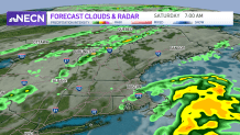
An offshore storm, which could briefly become a named tropical depression, is spinning to our south. The outer bands of this disturbance will swing some scattered showers and perhaps a few downpours to southeast Massachusetts and Cape Cod Saturday morning to midday, before breaks of sun emerge.
Get New England news, weather forecasts and entertainment stories to your inbox. Sign up for NECN newsletters.
At the same time, a cold front will push from northwest to southeast across the region, sparking a few showers and thunderstorms. I’m not anticipating widespread severe weather, but I would have a backup plan to duck inside should you need to Saturday afternoon and evening (north to south).
If you’re headed to the beach this weekend, keep in mind that the surf and swell from that offshore storm means waves will be a bit rough and the rip current risk is elevated. With no lifeguards at the beach this time of year, it’s especially important to keep a close eye on the kids if they decide to take a dip.

Behind the front, delightful air will arrive to the region on Sunday. Expect ample sunshine, low humidity and highs in the 70s – enjoy!
High pressure will stick around for the beginning of next week, too, so another beautiful couple of days are likely on Monday and Tuesday.
The first day of fall on Wednesday brings an increased risk of showers and storms by evening, and it will linger into Thursday and maybe even Friday morning. Temperatures will be around or just over 70 for the end of next week and weekend too.