
While all eyes in the weather world remain on Major Hurricane Ian in the Gulf of Mexico and closing in on Florida, New England remains completely removed from the fray.
A swirling, cold, upper level storm continues to be the dominant player in our weather setup, pinwheeling various energetic disturbances aloft through our New England sky, bringing periods of clouds and occasional raindrops. Although Tuesday is no exception to that recent pattern, the disturbance for most of central and southern New England was overhead Tuesday morning with clouds and sprinkles, set to depart for strengthening sun and pleasant air with highs in the lower 70s by afternoon.

In northern New England, clouds will continue to build through the afternoon, with some scattered showers developing out of the mountains and wandering through our valleys with highs in the 60s.
Get New England news, weather forecasts and entertainment stories to your inbox. Sign up for NECN newsletters.
A severe thunderstorm warning was issued for southeastern Maine Tuesday afternoon but has since expired. Click here for the latest weather alerts.
Overnight Tuesday night, a west-northwest wind will bleed cooler and drier air from Canada as a dome of high pressure, or fair weather, builds into the Great Lakes.
Daytime highs will drop only a few degrees Wednesday as compared to Tuesday, with many towns still nearing 70 degrees, and the air will still have enough moisture that morning sun will blend with puffy afternoon cumulus clouds as one more energetic disturbance arrives aloft, dragging a weak cold front at ground level, touching off a few sprinkles and light showers across the region.
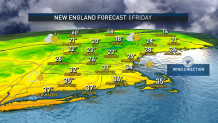
By Thursday and Friday, cool and dry fall air eliminates showers from the forecast entirely with high temperatures in the 60s, and this dome of dry air is critically important to our forecast, serving as a protective dome from Hurricane Ian’s moisture to our south. While some of the Hurricane’s high-altitude clouds will ride over our fair weather dome by Saturday, rain will remain in the Mid-Atlantic, and even Sunday brings only a building chance of showers in far southern New England late in the day. If New England is to see any showers at all from Hurricane Ian’s remnant, it’s likely to be early next week, and the chance of showers is reflected in our exclusive First Alert 10-day forecast.
Meanwhile, Florida remains in the line-of-sight for this intense hurricane. Predicted to make landfall along Florida’s west coast somewhere north of Fort Myers and likely near Tampa on Thursday, widespread damaging wind with nearly state-wide power outages, life-threatening storm surge along the western coast, flooding rain particularly in northern Florida and widely scattered tornadoes are all expected. Our First Alert Team will continue to keep you up-to-date with live information and reports in our broadcasts.
