
Winter’s not done yet. It’s only the end of March after all. A biting wind, record cold high temperatures and snow showers are all a part of the weather story today. Scattered snow showers, while not that widespread in coverage will drop a quick coating in the communities they do blow through this evening, creating slippery travel on untreated surfaces and briefly reduced visibility. So use caution and take it slow on the roads if you encounter them.
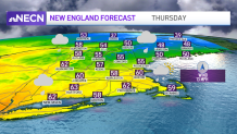
Meanwhile, the biting wind continue to gust to 35 mph and will do so tonight and tomorrow too. That means with temperatures dropping into the teens for most of us tonight, wind chill values will be in the single digits as we wake up – so bundle up the kids at the bus stop! Tomorrow won’t be quite as chilly as today; expect a wind chill near 30. The wind subsides on Wednesday and shifts direction to blow out of the southwest, which will allow our highs to climb into the 40s.
Get New England news, weather forecasts and entertainment stories to your inbox. Sign up for NECN newsletters.
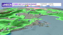
Increasing clouds and a few evening and overnight mixed showers are actually a signal of mild air returning to New England. We’ll be pushing 60 on Thursday and Friday, though the warm up comes at a price. We’ll be dodging some rain drops Thursday into Friday as scattered rain showers slide through. The weekend will be a bit cooler (50s) but looks dry and next week should see temperatures slightly above normal with pretty minimal shower chances.
