


Sunday night: Overnight showers through sunrise. Slippery commute. Lows in upper 40s. Monday: Rainy morning, highs in low 60s, showers heading into NE for the afternoon.
Sunday is another cool day with highs nearing 60 but this time we get to enjoy more sunshine! Fortunately, no rain chances for us this afternoon, although cloud coverage will start building up in the evening hours.
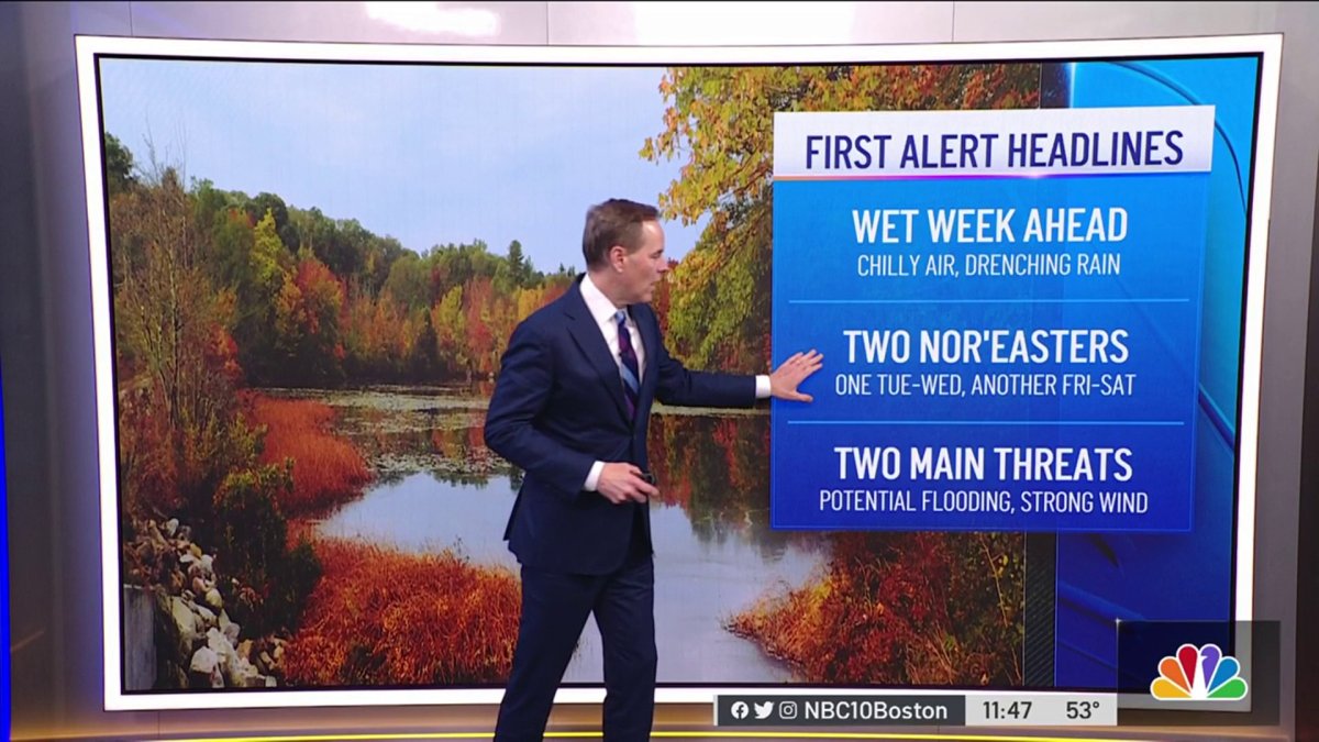
From Sunday night into next Sunday, we have showers on our Exclusive 10-day forecast unwilling to leave. We have three First Alert stamps for Tuesday, Wednesday and Saturday.
Sunday night we’ll see the first drops of what plans to be a rainy week ahead, and there's the potential for two nor'easters this week.
Get New England news, weather forecasts and entertainment stories to your inbox. Sign up for NECN newsletters.
Forecasted rainfall totals are likely to add up to more than 3-5 inches in several spots. Showers start rolling into western New England after 10 p.m. and will linger on through Wednesday.
That’s right: rain, rain and more rain.
With the light rain moving in ahead of the first storm Sunday night into Monday, it's not a huge problem for the Monday morning commute. In fact, we're expecting a lull in the rain by Monday afternoon.
Weather Stories


Heavy rain breaks out from the storm's second act Monday night into Tuesday.
Winds will ramp up, too, gusting 50-60 mph along the coast (possibly 70 mph on Cape Cod), and 40-50 mph elsewhere in the region.
There is a high wind watch already up across eastern Massachusetts. With many leaves still on the trees, and this being the first storm of the season, there could be scattered power outages across New England.
The forecast could improve a bit Wednesday or Thursday before the next storm moves our way. This could turn out to be a weaker storm, but could potentially produce another 1-2 inches of rain.
A warm front makes its way into the area Monday but the low pressure system will push in by Tuesday bringing the heaviest precipitation pockets.
Thursday might be the day that we get to have a brief break but it will overall be a cloudy and wet week.
Minor coastal flooding is expected Tuesday and Wednesday afternoons because of a prolonged ESE flow which will cause wave heights to come up near 13 feet on our south-facing shores by Tuesday. This could not only cause coastal flooding but also erosion and small craft advisories. The increased surge will continue through Wednesday.
With the week ahead not looking great weather-wise, Sunday is a great opportunity to begin with home preparations like checking your roof for any leaks, basement, trim the trees near your home and even clear out any debris obstructing a proper drainage flow surrounding your home.
If your windshields are working properly and your brakes are doing good, you’re good to go. Remember that for Tuesday and Wednesday -- the days with the heaviest rainfall -- we’ll likely see flooded streets. Stay away from these flooded roads and look for alternate routes.


