
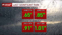
Wednesday's rain is like a long lost friend. It’s been a long while since we’ve seen this kind of wet weather. In fact, Boston hasn’t seen more than a half inch of rain since June 27, and just under an inch fell back on June 9. Badly needed, but just a drop in the bucket for the drought that continues to ravage the area.
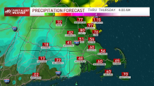
As low pressure moves into the Gulf of Maine, the showers will continue to pinwheel back across southern New England during the course of the day. This will mean some lulls at times (with light mist or drizzle) and some bouts of light to moderate rain at others. Gusty winds along the coast could reach 30 mph, and on the outer Cape & the Islands we’re seeing winds surge to nearly 40mph at times. For this late in the summer, this is an unusually solid (non-tropical) storm system.

Get New England news, weather forecasts and entertainment stories to your inbox. Sign up for NECN newsletters.
And it’s only here for a day. As it spins farther north into Thursday, our weather will improve from the get-go. Rainfall amounts will vary in this kind of setup. Your best bet for a steady, beneficial rain is along the coast, Capes and Islands. Just a short jaunt westward – likely beyond 128 – there will be more frustration and disappointment than sighs of relief and gratification. It’s here that the showers will run out of steam as they glide in from the ocean. The buck must stop somewhere, and it’s here that we have to draw the line.
We dry out Thursday and look ahead to more summer weather to finish the work week. This should carry into the weekend – with humidity to boot. Summer isn’t ready for its closing act yet.
