Refreshing air invades our region after record heat for some, cool temps for others and severe weather at times.
In Boston we did not see record breaking heat due to the sea breeze, 71 on Saturday and 89 on Sunday. Worcester did tie the record both days 88 and 90, respectively.
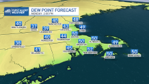
Today is another story. After the cold front that passed, we begin the work week with refreshing air and dew points in the 50s. Temperatures in the mid to lower 70s, cooler along the coast due to a high pression system over northern New England. Overall, a lovely day with the much-needed relief from the heat for most.
Get New England news, weather forecasts and entertainment stories to your inbox. Sign up for NECN newsletters.
Overnight we’ll see clouds increasing in association with some shortwave energy. This could trigger light rain along the south coast late tonight.
As we head into Tuesday, another cool and dry day. The onshore flow will be responsible for the cooler temps along the coast.
Do expect rather chilly air Wednesday and Thursday morning for this time in May. We’ll start out these days with clouds in the morning, which will burn off and allow us to enjoy plenty of sunshine.

Latter part of the work week will allow warmer air to filter into the region with a south/southwesterly flow. Temperatures and humidity will be on the rise with readings around 70. A front will push through providing the possibility for a few thunderstorms.
By the weekend, we’re expecting dry conditions for Saturday and Sunday the heat and humidity start to build back again in the upper 70s and lower 80s.