
Ian’s remnants keep the top of the headlines this weekend as wind and rain threaten southern New England and the coasts.
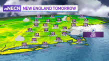
With cloudy skies taking over much of central and southern New England, as well as persistent rain south, temperatures will remain in the 50s today as we watch for rainfall amounts that may exceed two inches south with locally higher numbers running up around 3 inches possibly.
The cutline of that rain is around the Mass Turnpike. Just south of it, we’ll see the steadiest rain and the higher potential for recurring showers, while north of the pike… drier conditions come along by the late evening and into tomorrow.
Get New England news, weather forecasts and entertainment stories to your inbox. Sign up for NECN newsletters.
Gale warnings and watches will go into effect along the coastline early Sunday into Monday. Strong winds will cause hazardous seas which could capsize or damage vessels and reduce visibility. Mariners will be suggested to secure the vessel for severe conditions and avoid the open waters.
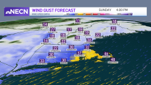
Gusts will go as high up as 50 mph near Nantucket and the southeast shore with up to 40 mph wind gusts near the coast. Gusting near 30 mph inland and watching for the wind chill to drop into the low 30s tomorrow night.
Weather Stories


u003cemu003eSign up for our u003c/emu003eu003ca rel=u0022noreferrer noopeneru0022 href=u0022https://www.nbcboston.com/newslettersu0022 target=u0022_blanku0022u003eBreaking newsletteru003cemu003e u003c/emu003eu003c/au003eu003cemu003eto get the most urgent news stories in your inbox.u003c/emu003e
Going over temperatures, our departure from normal is below 14 degrees in some communities south, which leads us to wind chills in the low 50s to upper 40s tomorrow afternoon and temperatures that will remain in the 50s through Monday. Ian’s remnants may meander offshore to our south from Tuesday through Wednesday and perhaps produce a few showers along the Cape and the Islands while drier conditions will prevail further north.
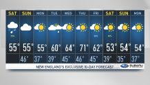
Temperatures by Wednesday should jump into the 60s and possibly near or reach 70 by Thursday before another dip comes in for the second half of the work week.
