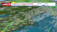
A cold front will continue to push into and through New England later Monday, sparking some thunderstorms along its path. A few storms could become damaging with wind gusts and localized flooding the primary concerns.
It’s not worth cancelling outdoor activities, but certainly have a backup plan to seek shelter indoors should you need to.
Any leftover storms around sunset should tend to fizzle out as we lose the daytime heating and instability. Gradually, less humid air arrives Monday night, and the dewpoints will continue to lower Tuesday. Expect filtered sunshine and highs in the 80s for many of us.
Get New England news, weather forecasts and entertainment stories to your inbox. Sign up for NECN newsletters.
Wednesday brings increasing and thickening clouds ahead of Ida -- her remnants will pass somewhere close or just south of New England on Thursday.
A flash flood watch was issued for Rhode Island, much of northern Connecticut and southeastern Massachusetts from Wednesday afternoon to Thursday afternoon, with the National Weather Service warning that streams and small rivers could swell amid high rates of rainfall.
See all weather alerts in your area here.
Heavy rain and wind gusts to 45 mph at the coast will result in pockets of localized flooding and isolated wind damage here. The waves will build as well and some beach erosion is possible.
It’s still early to say exactly how much rain we’ll see, but in general, southern New England could see a widespread 1-3 inches, with locally higher amounts. The farther north you go, amounts should taper off pretty substantially.
On Friday, as the low pressure center departs, we’ll clear the skies out, making way for high pressure to build overhead. That means Labor Day weekend is looking good!
Saturday and Sunday look dry for now, with low humidity and highs in the 70s. Much of next week will be in the 70s as well with some thunderstorms possible later Monday and perhaps again around midweek.