The giant storm that produced record snow and cold across the Midwest and the south, is heading our way tonight into Tuesday. As we sit over the boundary of mild air south and cold air north, little waves of precipitation continue to move through this evening with light sprinkles or freezing drizzle.
The main event is between 8 p.m. tonight and 2 p.m. Tuesday with freezing rain, sleet, rain south and snow north.
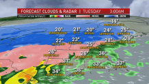
Temperatures overnight stay below freezing from Hartford to Worcester, to near Boston, and across New Hampshire and Maine. South and east our temperatures slowly rise which means all rain for Rhode Island, coastal Connecticut and southeastern Massachusetts.
The wintry mix and freezing rain heads into northwestern Connecticut, southern Vermont, western and central Massachusetts, southern New Hampshire and Maine tonight.
Through Tuesday morning, the ice situation will vary from spot to spot. Around Boston, a glaze of ice is possible, before getting washed away mid morning.
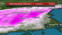
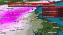
The Route 2 corridor, Worcester County, northwestern Connecticut and Hartford, southern Vermont, New Hampshire and Maine will see 0.3" to 0.6" of ice accretion.
It doesn't take much to slick up roads and create a skating rink with lots of accidents (0.1"), but when you get about 0.5" of ice that is when power outages and damage occurs.
The ice will linger across parts of New England through early afternoon until temperatures rise on a gusty south wind.
The South Coast may see highs in the mid 50s, in fact, while southern New England reaches the 40s by Tuesday afternoon. The heavy rain there may add up to around 1".
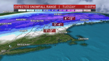
Northern New England and the North Country will see all snow. A foot of snow is forecast near the border.
Watch for refreezing and black ice Tuesday night as temperatures fall to freezing or below for all.
We have a nice break in the storms for Wednesday with some sun and highs around 30 degrees. Then we gear up for round two for the week.
Another storm system tracks through New England Thursday into Friday. This one is showing signs of more snow on the front end for even southern New England, before changing to a mix or brief rain.
Northern New England again will see all snow with another several inches possible.
The next weekend will be dry just in time for any plans you have for travel or heading outdoors.