
The Vernal Equinox marks the beginning of astronomical spring, and happens Monday. While meteorologists consider the spring season to run from the start of March to the end of May based on average temperatures, astronomical spring relates to the sun.
On the equinox, the sun is directly above the equator on its trek to its northernmost point with longest daylight in the Northern Hemisphere on the Summer Solstice in June. On this day of the Vernal Equinox, we’ve already crossed the 12 hour daylight threshold this past weekend, but Monday, the sun rises due east and sets due west – it won’t do that again until the start of astronomical autumn.
Ever heard about how you can balance an egg on the spring equinox? It’s true! Just no more true than any other day – that’s an old “wives tale” and there’s no greater chance to make that feat happen on the equinox than any other day.
Get New England news, weather forecasts and entertainment stories to your inbox. Sign up for NECN newsletters.
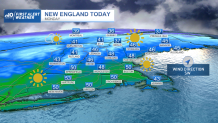
As for the weather, abundant dry air from a huge dome of high pressure over the Eastern two-thirds of the U.S. will keep lots of sunshine in the forecast Monday and Tuesday, though the dry air does have some other consequences, particularly when combined with a busy breeze from the southwest on Monday.
In areas where there is no snow, last year’s dead brush and vegetation dries out for an increased brush fire danger, particularly true in Southeast and far southern New England, while pollen counts due to juniper and poplar are rising.
Weather Stories


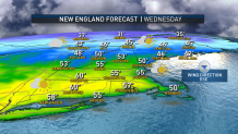
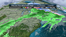
The dry air also will help to slowly dehydrate the body, making a water bottle a smart accessory for adults and kids alike through the first half of the week, while temperatures rise into the 50s for many Monday, and 55 to 60 degrees in southern New England Tuesday. Clouds will increase Wednesday as a disturbance moving east out of the Great Lakes approaches New England and picks up just enough moisture to deliver a few showers Wednesday night, with a follow-up disturbance bringing renewed showers and a cold front Thursday.
That cold front may deliver just enough dry air to lower the shower chance Friday, but a stronger storm system carrying Gulf of Mexico moisture will head into the Northeast on Saturday, bringing rain into the forecast and encountering enough lingering cold air on the front side of the storm to deliver a combination of rain and snow to New England – it’s early to estimate where the rain/snow line will start, but may be as far south as northern Massachusetts depending on how things come together, but more likely will be somewhere from the Berkshires to central or southern New Hampshire.
Some lingering showers are possible Sunday but the vast majority of the precipitation should be over by then, and a pattern favoring an increased chance of showers lasts into early next week, with a weak Bermuda high pressure dome trying to feed warmth north while Canadian cold isn’t ready to give up, so showers develop along the clash of air near New England.
