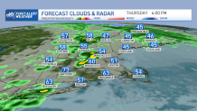
We saw widely varying temperatures across New England today that prompted severe thunderstorm warnings to the west.
Severe storms and showers possible
We dug into the 70s in areas of Connecticut, with temperatures staying in the 40s across much of the northeast. The fact that we have such a significant contrast in our highs with instability across the west triggers our storm potential this evening for some in western Massachusetts and Connecticut.
Get New England news, weather forecasts and entertainment stories to your inbox. Sign up for NECN newsletters.
While the onshore flow is keeping temperatures in the 40s and 50s from Portsmouth into Boston, our storm development decreases significantly as these storms move eastward through the evening and into tonight. As these march over eastern Massachusetts and southern New Hampshire, they’ll interact with cooler temperatures, and we'll see more stable weather for eastern Massachusetts. Expect Showers and possible thunder in isolated spots but the damaging wind potential will step down by then. It’ll be a cool night, we’ll break more clouds allowing for higher radiational cooling rates and dropping our temperatures to the 40s and 30s.
What to know about Friday morning's weather
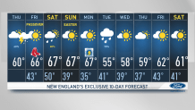
This will bring a lovely Friday - we’ll enjoy mostly sunny skies through the late morning and afternoon with highs reaching the mid and upper 60s. This is perfect for our Red Sox game at Fenway Park and those observing Passover begin. Our winds will remain from light to moderate with a cold front that will await until tomorrow night to bring showers in the far north country with some more scattered showers on Saturday.
Weather Stories


On and off shower chances this weekend
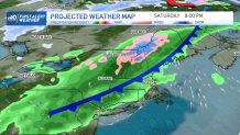
Our weekend is bringing interesting weather; our highs rise to the 60s on Saturday, which will be warmer than Sunday. But the chance of showers takes it time to reach central and southern NE that day; that means that much of the area will enjoy a mostly dry afternoon with mild temperatures. Easter Sunday will feature a changing pattern, we could be watching for some showers filling in through the afternoon. Highs will remain in the 50s with a NW flow and a breezy afternoon.
For Monday, we’ll be having cool temperatures to kick off our Marathon in the 40s and we’ll rise our way up to the 50s through midday and afternoon. Rain chances will remain low by then. Tuesday will feature a return in rain chances with highs mostly staying in the upper 50s through much of our Vacation week. Stay tuned with our First Alert Team for all the updates and our Exclusive 10-day forecast.