This morning’s rain is out of here and now breaks of sun have been emerging across parts of the region, boosting our temperatures into the 70s and 80s.
Sunshine combined with humid air in place will help fuel a few renewed popup thunderstorms, mainly in the 2 p.m. to 7 p.m. timeframe. Not everyone will see a storm, but a few could contain locally heavy rainfall, lightning and brief gusty wind, so be prepared to seek shelter if necessary.
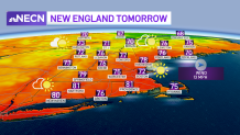
This evening the front will push off the coast and leading to clearing skies and lowering humidity across the board. This sets us up for an absolutely fantastic day tomorrow; sunshine, low humidity and highs in the 70s to around 80.
Get New England news, weather forecasts and entertainment stories to your inbox. Sign up for NECN newsletters.
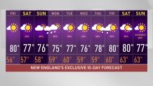
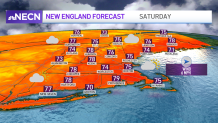
Overall, the weekend is looking good too! Saturday should be mostly dry with varying amounts of sun and clouds and highs in the 70s. While we can’t rule out an isolated shower, there shouldn’t be too much action.
Sunday will feature mostly cloudy skies, but despite that, our temperatures will still rise into the 70s. A disturbance will approach from the west late in the day, triggering some scattered showers and perhaps thunder, particularly in western and northern New England.
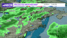
The front will swing through from west to east Sunday night into Monday, accompanied by showers, before we dry out Monday afternoon. Next week’s weather looks fairly seasonable and quiet, with highs in the 70s and a few showers possible. Our exclusive 10-day has next weekend on it already, so for those looking ahead (perhaps to Father’s Day), right now we see partly cloudy skies and a chance of showers on Saturday (not a washout). We’ll keep you posted on any changes.