Thunder huddled over the Merrimack Valley yesterday, so some spots got a drink of water. The rest of us saw some great cloud formations, but stayed dry. It’ll be a few more days before we see any more rain or storms threaten.
The theme revolves around fresh, dry air in the coming days. With the upper level low pressure system still spinning overhead, we’ll see the sky congest with afternoon clouds through tomorrow. Nothing alarming, but it will cut back on the sun a bit.
Nice breezes blow from land – not sea – so our mildest temps will stay near the coast (Cape Cod is a bit cooler).

Get New England news, weather forecasts and entertainment stories to your inbox. Sign up for NECN newsletters.
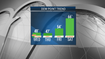
Next threat for storms would be on Saturday as a front approaches. Humidity will climb a bit Friday, but it waits until the start of the weekend to peak.
While the storms could be strong, it’s still too early to tell where they may form and how numerous they may be. For that reason, it’s probably wise not to cancel plans.
As we saw with the storms yesterday, they may only take up a small portion of the day, and/or may not hit your specific town/city at all. Have a great Wednesday!


