
This weekend is a perfect summer weekend if you are headed to the beach!
If you don’t have A/C, it’s going to be uncomfortable inland. This morning we notice the humidity is higher again with areas of fog. The fog rolls out by late morning and then the sun heats us up fast. The strongest sun angle of the year, combined with our latest sunsets (8:25 p.m. tonight in Boston), and it’s a true summer feel.
Highs today will be in the 80s thanks to a sea breeze, in the low 90s inland, and muggy. A few clouds develop, but we don’t anticipate any showers popping up as there is drier air in place and high pressure in control to our south. Lows tonight will be in the 60s with another muggy night on tap.
With more morning fog, we start off cloudy Sunday morning but then become sunny later on. Highs will be even hotter, in the upper 80s at the coast thanks to a sea breeze again, and mid 90s inland. Sunday is a tad more humid than Saturday, too. The Cape and the coast is where you want to be, with Cape Cod temps in the 70s this weekend.
Get New England news, weather forecasts and entertainment stories to your inbox. Sign up for NECN newsletters.
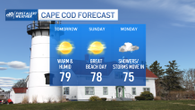
Our next chance for rain or thunderstorms will be Monday as a cold front approaches. We are leaning towards more garden variety showers versus thunderstorms due to poor lift and the timing of the frontal passage. The showers will be welcome anyway as we have continued drought conditions in southern and eastern New England. For now, we could squeeze out upwards of half an inch Monday into Tuesday.
Temps Monday reach the low 80s prior to the rain, then we cool off to the 70s for Tuesday. Summer heat is here to stay, though, as we return to the 80s and low 90s heading towards the 4th of July weekend. Rain will be around for Saturday and Sunday, but the timing is not locked in just yet. For the 4th, our 10-day outlook has a 20 percent chance for rain, partly cloudy, and highs in the low 80s.
