
A beautiful day is on tap for the region, with high pressure still in control of our weather. The low level smoke from Nova Scotia wildfires will not be as prevalent Wednesday, though the sky may look hazy at times in the afternoon.
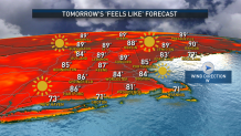
High temperatures will be about 10 to 15 degrees warmer than Tuesday across the board: in the 70s and 80s from the coast to the interior, respectively. Some low level clouds and patchy fog will redevelop Wednesday night, particularly south of the Mass. Pike, but will burn off quickly Thursday, giving way to sunny skies Thursday. And it will be hot! Expect highs around 90 degrees for many of us, though the South Coast to Cape Cod will be cooler and in the 70s. Beach day, anyone?
Friday will be similar in terms of temperature, but an approaching cold front will bring building clouds and some developing showers and thunder, mainly from mid afternoon through the evening. Not everyone will see a shower or storm, but they will be scattered in nature, so it’s worth having the umbrella on standby.
Get New England news, weather forecasts and entertainment stories to your inbox. Sign up for NECN newsletters.
The showers and storms mark the leading edge of dramatically cooler air that will arrive for the weekend. We’ll only be in the upper 50s to lower 60s – around 30 degrees cooler! Some showers are likely to linger into the first part of Saturday, though a drying trend is likely for the second half of the day.

Sunday should be mainly dry, aside from an isolated shower from the south shore to Cape Cod and some potential stubborn clouds at the coast.
Weather Stories


Next week features a bit of an unsettled pattern with daily pop up shower chances and highs slightly cooler than average for the first week of June as seen in our exclusive 10 day forecast.
