
After a cloudy end to Saturday, Sunday looks to be mostly sunny. The day will be rather calm with highs near 86°. While an isolated shower or two seems possible, the day is mostly dry.
A much more potent system arrives Monday that brings about widespread rain. Across the Western U.S., a strong area of high pressure continues to settle in. Storms travel along the northern extent of the high and funnel into the region.
The intensity and track warrant monitoring. Showers, thunderstorms and isolated severe weather are possible on Monday afternoon into the evening, and Tuesday morning.
Drier air sweeps in Tuesday afternoon and evening. This should allow another day of clearing skies with highs in the upper 80s. That will start our stretch of attempts to reach (or pass) 90°. If all goes according to forecast, this will ring in the warmest week of the year so far, and our first heat wave since August 2021. Given climatology alone, this is par for the course.
Get New England news, weather forecasts and entertainment stories to your inbox. Sign up for NECN newsletters.
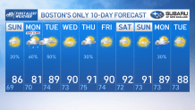
We’ll still be in a moisture rich environment with dewpoints in the 70s until Friday. Coupled with temperatures in the 90s, it’s very possible heat indices reach or surpass 100°. Ridging across the west holds for much of the week, with another chance for rain passing through on Thursday.
