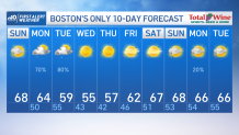
The high pressure protecting us today has brought a gorgeous Sunday with highs in the upper 60s and plenty of sun.
Now, more clouds are starting to march into western New England and bring humidity with it; setting up the stage for showers Monday.
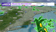
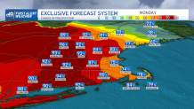
We’ll see light to moderate showers becoming scattered and rolling into Connecticut, Rhode Island and Eastern Massachusetts by midday on Monday. While some downpours may tag along with this system, most of the heavier rain is trending to yield upon western Mass. as well as central/northern Vermont and New Hampshire.
Get New England news, weather forecasts and entertainment stories to your inbox. Sign up for NECN newsletters.
The Cape is likely to receive a good shot of rain overnight into Tuesday with most of the activity exiting by Tuesday afternoon/evening. While the front exits on Tuesday and takes most of the clouds with it, it will leave cooler temperatures behind.
Fortunately for us, we’ll enjoy rays for days! So with temperatures in the 50s both Wednesday and Thursday so it won’t feel too bad with the bright sun shining upon most of New England and allowing us to warm up back to the 60s by the end of the work week.
Interestingly enough, much of the country will see a “quiet” week. The emphasis will be that meandering low swirling over the great lakes. The frontal boundary that produces showers from Arizona to Tennessee today through tomorrow will shift south Tuesday and a high pressure will take over much of the US. Our following weekend is picturing to be stellar, highs in the upper 60s with dry conditions and more sun. Enjoy!