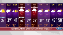
Clear skies will give way to radiational cooling Friday night, allowing for temperatures to drop into the 20s along weaker wind speeds.
As the winds continue to subside overnight, Saturday morning will feel frosty -- in the teens north and closer to the 20s in the south.
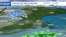
On Saturday, we’ll be watching increasing clouds as a trough makes its way across the north, allowing for scattered snow showers there, with lingering showers trying to make their way into western Massachusetts.
Get New England news, weather forecasts and entertainment stories to your inbox. Sign up for NECN newsletters.
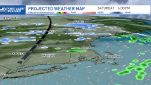
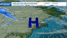
While most of the south will remain dry throughout the weekend, Sunday will be dominated by a high pressure system that will allow for sunny periods and a rain-free afternoon.
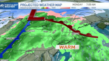
First Alert Stamps are on Monday and Wednesday in our 10-day forecast. These will be two different storms: one will provide warmth, rain and possible thunder while the other will bring more snow and cold temperatures.
Monday’s system will push in a warm front that will increase our moisture, bring wind from the southwest and provide warm temperatures that will rise into the 50s and 60s.
Wind gusts will speed close to the 50 mph and might even reach 55 mph in the most affected sites.
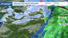
While Tuesday is expected to remain dry and cool, Wednesday’s storm will bring snow, wind gusts and some possible rain into the south.
The end of our exclusive 10 day forecast features below average temperatures through Friday with an increase for next weekend, as warmer weather makes a come back.