
A pleasant and breezy afternoon continues across much of the region with the exception of far northern New England where clouds and some showers continue.
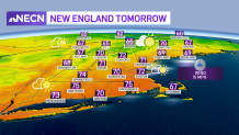
Tonight, the skies clear out for everyone and low temperatures will drop to the 30s north and 40s south. Sunshine will greet us tomorrow and allow our temperatures to rebound quickly to 70 degrees, and there will be less wind too.
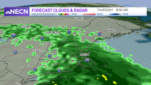
Clouds advance in by tomorrow evening and thicken overnight ahead of some rain. For some of us, it’ll begin overnight into pre-dawn Thursday, and linger until early afternoon. Even after that, aside from a few breaks in the cloud cover by sunset, we’ll remain overcast in many areas. So have the wet weather gear with you for the morning and midday Thursday.
Get New England news, weather forecasts and entertainment stories to your inbox. Sign up for NECN newsletters.
The wet weather does mark the start of returning warmth that will be felt Friday, then especially this weekend! In fact, we could be talking about record-breaking highs in the lower 90s on Saturday. Combine those temperatures with a bit of humidity and it will certainly be a day you’ll want to take it easy.
Sunday won’t be quite as hot, but we’ll still be well into the 80s. Both weekend days will feature a threat for some thunderstorms, especially in far northern and western New England – so keep an eye to the sky and remember "when thunder roars, go indoors."

Next week looks fairly quiet and cooler with highs in the 60s to lower 70s and a few shower chances, but no washouts.
