When the snow is coming to New England
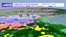
We’ve made a sharp return to reality after record warmth to kick off November and several warm days as of late. Now, the chill has settled back in and it’s here to stay, which means that you knew that it was only a matter of time before we’d be talking about snow! In fact, the morning sun tomorrow will fade as clouds gradually increase and thicken for an overcast afternoon – the first sign of increasing moisture aloft ahead of a storm center developing out of the Gulf of Mexico and Lower Mississippi River Valley tonight and reaching a position near Cape Cod by Wednesday.
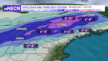
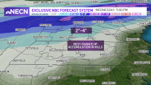
6-12 inches of snow possible in Northern New England
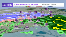
As moisture increases, clouds will be followed by rain and snow – with an easterly wind and a relatively warm ocean, snowflakes will be reserved for the deep interior, and while they may only briefly make an appearance in Northern Connecticut or southern Worcester County Massachusetts, they will last longer the farther north one is. In fact, our First Alert Team is predicting a widespread 6”-12” of snow in Northern New England with amounts decreasing to the south, but likely a couple of inches in the Monadnock Region and Berkshires, and even an elevation-dependent coating to 2” in the Worcester Hills to Southern New Hampshire, with higher terrain seeing the higher amounts.
Get New England news, weather forecasts and entertainment stories to your inbox. Sign up for NECN newsletters.
Travel impacts across New England
Weather Stories


What impact will this all have on travel? While roads will remain wet near and inside Route 495 and in much of Southern New England, the high terrain locations will see slick conditions developing predawn Wednesday into Wednesday morning, and snowier spots of Northern New England will contend with full-on winter storm conditions Wednesday. As quickly as the storm rolls in overnight Tuesday night, it rolls out Wednesday evening, leaving a return to cool, dry and quiet weather for the end of the week and start of the weekend.
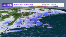
Gusty winds also possible with the snow
And what about the wind? As the storm center makes a pass near Cape Cod on Wednesday, our wind will increase out of the northeast and then flip to blow out of the north then northwest behind the storm center. I don’t anticipate big issues because of the wind, but a few small limbs or branches may come down with some gusts topping out near 40 mph briefly Wednesday on Cape Cod and along the coast of eastern Massachusetts Wednesday evening.