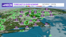
Downpours, thunder, hail and graupel remain a possibility through this afternoon. We’ve had reports of graupel already in Connecticut and Massachusetts as well as lightning and active winds.
Stay safe this afternoon: "If thunder roars, go indoors." Wind gusts will exceed 25 mph as we see these showers and embedded downpours pushing into the northeast towards Maine through the afternoon and into this evening, for which many in central and southern New England will get to enjoy a nice sunset.
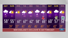
Temperatures today have reached the mid and upper 50s for some and we’ll drop a few degrees tomorrow. With a cooler day on tap, Sunday will feature highs in the mid-50s with some upper 40s in Vermont. Tomorrow’s a different scenario though, we’ll see mostly sunny skies in the late morning hours through early afternoon with the chance of some isolated rain. These light and brief showers will march rapidly towards the east as the afternoon progresses and our winds will once again fill in close to 20-25 mph.
Get New England news, weather forecasts and entertainment stories to your inbox. Sign up for NECN newsletters.

With am upper level ridge moving in on Monday, we’ll enjoy a calm and mostly sunny day, highs will rise to the 60s again and we’ll begin a warm up stretching through much of the week. We’ll see above average highs on Tuesday, climbing to temperatures in the upper 60s that day- some spots could see highs nearing, if not touching, 70 degrees.

Our rain chances increase again on Tuesday and we keep the chances for showers on our exclusive 10-day forecast through next weekend. The opening game at Fenway Park on Friday will feature highs in the low 60s with the chance of showers. Easter Sunday keeps the chance of showers with highs in the 50s. and the forecast for our Boston Marathon keeps the 50s with a cool start to the day.

