
We have two storm systems affecting our area and two First Alert days. The first storm is grazing by southeastern New England and eastern Maine Friday. The second is running along the coast on Monday. Wind and waves will impact the northeast, as well as some rain or snow. In between these systems, we have the bitter cold and dangerous wind chills Saturday.
Friday's Storm
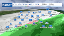
This storm is grazing by the northeast for Friday, affecting mostly southeastern Massachusetts with precipitation. Rain showers begin overnight, and spread northwest until hitting 128 approximately. Farther northwest, no precipitation from this one. Temperatures start off in the 30s and 40s in the morning and afternoon. Slowly, as the storm center heads away from us and strengthens, it will pull in colder air from Canada.
Get New England news, weather forecasts and entertainment stories to your inbox. Sign up for NECN newsletters.
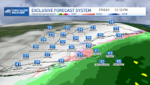
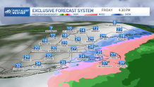
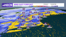
The center of the storm clobbers Nova Scotia and Newfoundland. Meanwhile, we see the rain change to snow in Boston and across Cape Cod before the precip. heads out Friday evening. Enter the wind! Damaging northerly wind gusts around 60 mph along the south shore, Cape & islands will crank up Friday evening, through Saturday predawn. Expect some outages and damage.
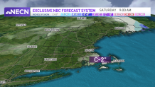
Bitter Cold
Weather Stories


The wind then ushers in bitter cold as temperatures crash Saturday morning. A flash freeze is possible in southeastern New England after the rain to snow from the afternoon. Temperatures fall to the single digits south and below zero up north. Wind chills of -10 to -25 will be found all over the northeast. These low wind chills mean frostbite can set in in 30 minutes or less for many areas Saturday. Highs only reach 5-15 degrees south, around zero in the north country. The wind slowly subsides by nightfall.
Sunday Into Monday Storm
Sunday we have a break from the intense weather with 20s and sunshine plus less wind, but Sunday night into Monday our next storm heads in. This one is likely to track along or just inside the coastline of the east, the center of the low-pressure system heading into western New England.
This storm will be messy, with temps in the 40s southeast and rain. Colder temps and snow is likely for northern and western New England. Several inches of snow will fall and some upslope snow may enhance our totals in the mountains too. The snow is all day long Monday, which is a popular ski weekend since it’s Martin Luther King Day. Stay tuned as the track may wobble slightly and then we could increase our totals for Boston from a couple of inches to several.
Wind speeds increase as the storm moves through Monday, southeast gusts around 40 then southwests gusts in southern New England. Northern New England will see more northeast to northwest winds. As for the coast, the wind will be offshore, no not anticipating coastal flooding. Waves off shore will be 10-20 feet so it’s a dangerous storm for mariners.
Our weather pattern quiets down after Monday, with temps in the 30s to 20s and a small system bringing in snow showers sometime midweek.
