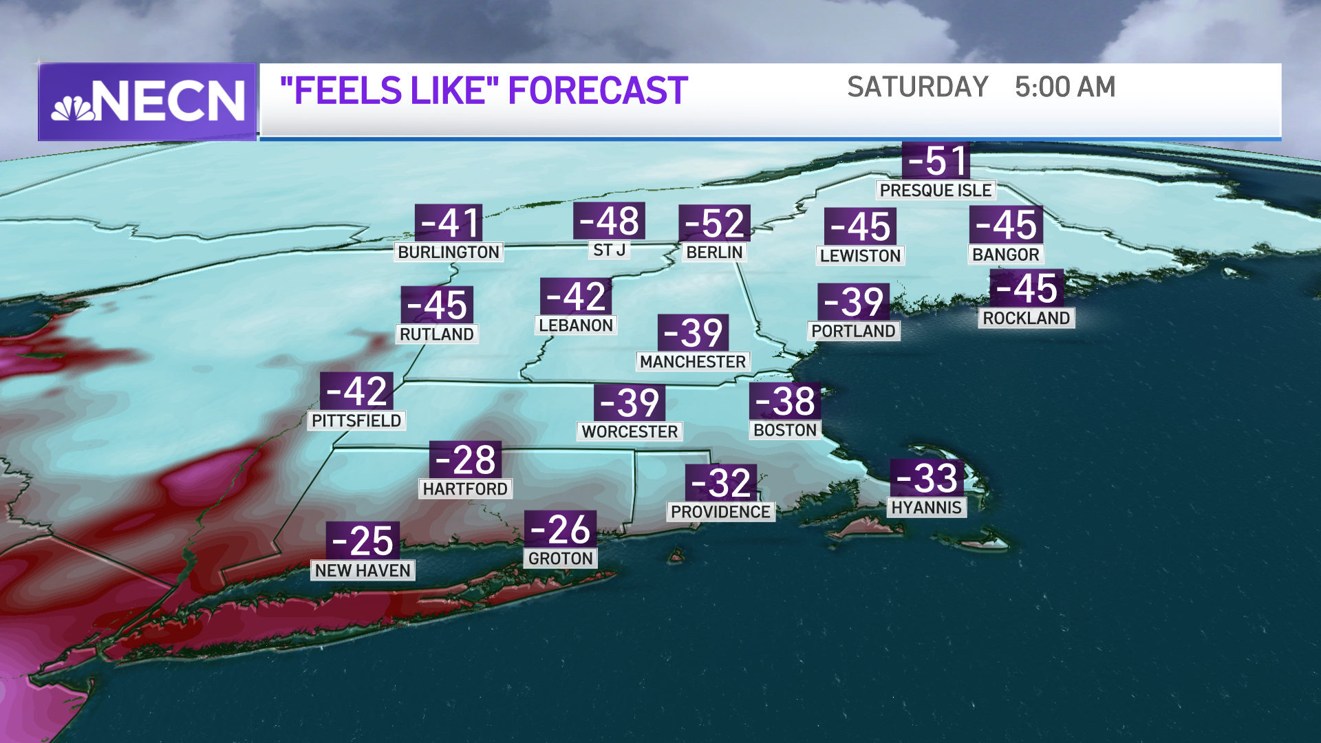
Our First Alert weather headlines this week features extreme cold, with the lowest wind chills since Valentine’s Day 2016. Other than hearing what it will feel like, we thought this would be an important time to explain what this wind chill actually is.
During winter and times of extreme cold, cities and municipalities make decisions based upon these extreme temperatures. Upon examination, decision support is far more difficult (and less effective) when using temperature alone. That standalone temperature doesn’t give a complete perspective. It only tells what the thermometer is reading.
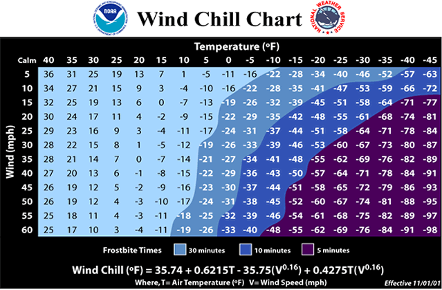
The wind chill, or feels like temperature, is based on the rate of heat loss from exposed skin caused by the effects of the wind and cold. As the wind increases, heat is lost, the body cools at a much faster rate, causing the skin’s temperature to drop.
Get New England news, weather forecasts and entertainment stories to your inbox. Sign up for NECN newsletters.
Similarly, imagine driving a motorcycle on a calm but cool day. When the motorcycle goes fast, skin that’s exposed will cool quickly as it’s losing body heat.
While not identical, its cousin during the summer is the heat index. Both are perceived temperatures on the body, though heat index takes into account atmospheric moisture.
Wind chill does not impact inanimate objects like car radiators and exposed water pipes, because these objects cannot cool below the actual air temperature.
Those exposed to dangerous wind chills run the risk of frostbite and hypothermia. Frostbite is a condition in which the body tissue actually freezes. The most common and susceptible parts are extremities such as fingers, toes and ears. Some symptoms include loss of feeling or a white or pale appearance. Medical attention is needed immediately, and those areas should be SLOWLY re-warmed. Hypothermia is an abnormally low body temperature (below 95°). Warning signs include shivering, memory loss, disorientation, incoherence, slurred speech and drowsiness.
Early wind chill research was conducted in 1945 by Antarctic explorers. They measured the cooling rate of water, which freezes faster than flesh. As a result, it underestimated the time of freezing and overestimate the chilling effect of the wind. The current index, implemented in 2001, is based on heat loss from exposed skin, and was tested (safely) on humans.
During the trial, 12 volunteers, male and female, were placed in a chilled wind tunnel, according to the National Weather Service. Thermal transducers were stuck to their faces to measure heat flow from the cheeks, forehead, nose and chin, while walking three miles an hour on a treadmill. Each person spent four 90-minute sessions in the tunnel, where the wind and temperatures were cranked up and down.
The Wind Chill Formula
Wind chill (°F) = 35.75 + 35.75V0.16 + 0.4275TV0.16
Where T = Air Temperature (°F) & V = Wind Speed (miles per hour)
Common cold weather alerts that you’ll see when temperatures are forecasted to be this low are:
Dangerous Cold Possible — Wind Chill Watch: Wind Chill less than -25°, for at least 3 hours (issued within 36-48 hours before expected temperatures)
Cold Weather Expected — Wind Chill Advisory: Wind Chill -15° and -24°, for at least 3 hours (issued within 24-36 hours before expected temperatures)
Dangerous Cold Expected — Wind Chill Warning: Wind Chill less than -25°, for at least 3 hours (issued within 24-36 hours before expected temperatures)