
Our pleasant stretch of weather continues with warm days, cool nights and low humidity.
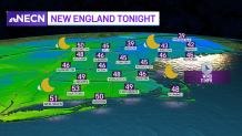
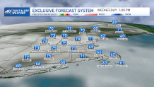
Tonight our lows again drop to the 30s far north, 40s and low 50s to the south under a mainly clear sky. Our wind direction changes a bit from the southeast tomorrow as a center of high pressure floats off to the east. The wind is calm enough at the coast that sea breezes develop in the heat of the afternoon. Highs will make it into the upper 60s at the coast and mid-70s inland for Wednesday.
Get New England news, weather forecasts and entertainment stories to your inbox. Sign up for NECN newsletters.
On Thursday a warm front lifts through the northeast and this brings our humidity up again by the end of the week. The humid air really dominates Friday into Saturday, with dewpoints in the 60s. Our temps will be in the upper 70s both Friday and Saturday as a low pressure system approaches. This will bring in some summerlike thunderstorms for the start of our holiday weekend.
Saturday looks a little cooler and more stormy now as the cold front is very slow to exit. Storms will be around especially in the heat of the afternoon. The front washes out as it heads offshore sometime Saturday into Sunday. Highs stay in the 70s for Sunday and Monday with drying weather. Pop-up storms in the interior are possible again for Sunday. Monday seems to be drier with sun and 70s. Next week we see a little more of a warm-up with highs in the low 80s across the northeast. Stay tuned for updates.
