
Parts of southern New England could see some snow this weekend. And while not everyone will see flakes, the temperatures across all of New England will come crashing down to the 20s and 30s tomorrow afternoon for us all.
A north wind will keep the wind chills in the 20s tomorrow and the far northern communities in New Hampshire, Vermont and Maine will have wind chills in the single digits to teens in the early morning.
With a high pressure system settled over Canada, our wind will shift in from the Northeast Saturday. This cold air rushing over relatively warmer ocean waters will enhance the chance for precipitation. Temperatures along the coast will be key to whether we see rain or snow. Cape Cod and the Islands will remain mild with highs near 40, meaning rain is in the forecast for these areas. Higher up into Plymouth county and through Suffolk, temperatures begin to cool down to the 30s. With the evening temperatures dipping lower, the chance for ocean-effect snow will increase in the east and southeast for Massachusetts. Accumulation will be limited and could range from a coating to an inch.
Get New England news, weather forecasts and entertainment stories to your inbox. Sign up for NECN newsletters.
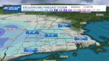
A better chance of snow will be seen on Sunday evening in western New England. Vermont, the Berkshires and Connecticut will be the first to see the snow. Accumulation amounts may range from 2-4 inches there. But as the snow may spread as far east as the Monadnock Region, Worcester county and the state of Rhode Island, a coating may be seen in the ground by Sunday overnight into Monday morning. Conditions may remain slick for our early Monday commute for which drivers would have to use extra caution.
The snow will exit early Monday and will leave us with highs with a wintry feeling through the afternoon; highs in the 30s along with increasing sun.
