
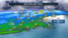
Fair weather ends our workweek Thursday and Friday, as dry and cool air spills southeast from Canada behind a second cold front, reinforcing the first push of new air that ushered out our midweek showers.
With the new installment of cool air, our clearing sky will allow temperatures to drop into the 20s overnight Thursday night, then only recover to the 40s, even under ample sun, Friday.
All the while, a squeeze will be on between a huge ocean storm over the north-central Atlantic and a huge high pressure dome over central Canada – each of which is impressively large and strong in its own right. The storm is creating waves of 40 to 50 feet over the open ocean and delivering 12-18 foot swell to New England’s offshore waters with 6-10 foot seas in near-shore waters building through the upcoming weekend, while the large high pressure dome is providing a steady feed of chilly air.
Get New England news, weather forecasts and entertainment stories to your inbox. Sign up for NECN newsletters.
In between the two, the difference in barometric pressure will crank up a north and northeast wind Friday through the weekend, with gusts on Cape Cod reaching 40 mph and coastal gusts, particularly Saturday and Sunday, reaching 35 mph.
This wind, combined with the cool air, will create a wind chill in the 30s at the warmest time of the day under Friday’s sun, then a wind chill in the 20s Saturday and Sunday! The other impact of a persistent northeast wind this weekend will be to carry ocean moisture into the coast as a deck of marine clouds for much of southern New England with a spray of cold rain showers from time to time Saturday and Sunday, especially inside of Route 495, while communities farther inland will stay cloudy and chilly, but are less likely to see much in the way of showers Saturday or early Sunday.
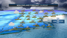
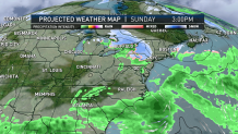
Northern New England stays removed from this marine air, with variable clouds and highs in the 30s Saturday and most of Sunday. Things change late Sunday, when a weakening storm system enters New England from the west, depositing two to four inches of accumulating snow in Upstate New York Sunday, then likely to drop a coating to two inches of snow in western Massachusetts and central/western Connecticut Sunday evening and night.
Since the storm will be weakening quickly, it’s unlikely to drop more than a coating in the eastern half of southern New England Sunday night, with a few lingering mixed showers of snow and rain leftover early Monday morning before shipping out for a fair and chilly finish to the day.
Cool air holds on until a midweek storm approaches next week, dragging moisture and warmth with it. But the substance of the antecedent cool air means this time around, it’s likely that not all of New England flips to mild rain like recent storms. While it’s still possible that happens in southern New England, at this very early juncture it seems quite possible northern New England would pick up some much-needed, natural snow, with central New England riding the line and to-be-determined. Our First Alert Team will keep you posted!
